野生动植物监测系统
1 引言野生动植物是生物多样性中不可或缺的重要组成部分,对维持生态平衡和人类社会的可持续发展起到关键作用。然而,由于环境破坏、人类活 ...
Application Background
Forest fire is one of the most important forestry disasters in the world. With the continuous development of China's afforestation, fire prevention has become the primary task. Forest fire has the randomness of abrupt and disaster. A short time can cause huge losses, and the economic loss caused by forest fires is almost immeasurable, and the damage to the ecological balance is almost irreversible. Therefore, once a fire alarm occurs, it is necessary to take the rescue measures at a fast speed. Whether the rescue is timely and the decision is right or not depends on whether the discovery of forest fire is timely and the analysis is Whether it is correct and reasonable, whether the decision measures are appropriate or not. Forest fire prevention must carry out the policy of "prevention first, and fight actively", so as to truly detect and solve it early. At present, the remote monitoring system has been widely used in the field of forest fire prevention and control. Based on the video image processing system, network transmission technology, intelligent identification and alarm technology, "smoke fire" analysis and recognition technology, the digital and intelligent integrated control technology of forest fire prevention and early warning is realized, which really achieves the purpose of forest fire prevention.
System Introduction
With the development of forest fire prevention and technology, more and more functional requirements for forest fire prevention are required. On the basis of realizing basic forest fire prevention function, the system of fire monitoring and management, IP broadcasting system, handheld terminal patrol system, automatic weather station and UAV can be added to the basic forest fire prevention and control system.
Forest fire video monitoring system is used for forest fire prevention turntable and the back-end monitoring management software to realize intelligent identification and automatic alarm fireworks, using the azimuth Angle and elevation Angle of turntable, the focal length of the telephoto lens and backend management software of GIS platform to realize automatic fire accurate positioning, through the camera and the video image transmission link and control signal transmission to the command center for monitoring, storage, management, a set of intelligent forest fire monitoring system. With the gradual increase of forest fire prevention system, the system can also increase the front-end handheld terminal to realize the real-time communication between the forest fire prevention and mobile terminal and the handheld terminal.
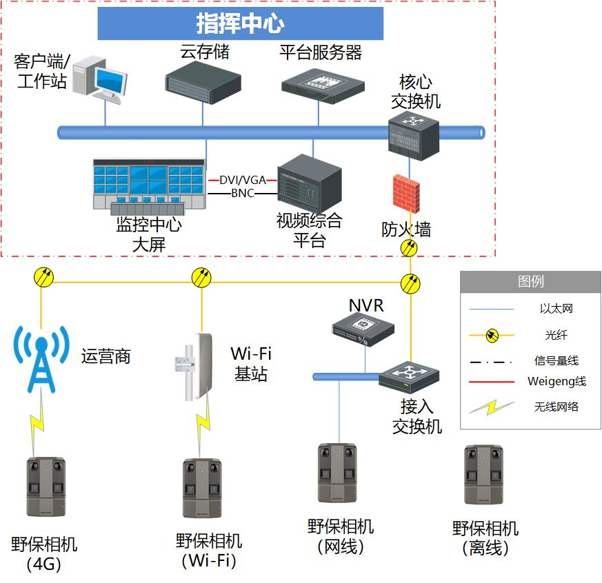
The video surveillance and warning system for forest fire prevention mainly consists of front end video acquisition system, power supply system, anti-theft system, lightning protection system, transmission system, command center system and so on.like this:
Software function
The forest fire identification
Through the front-end visible light and infrared thermal imaging and temperature measurement module for the monitoring area for 24 hours uninterrupted data collection, the data collected through the transmission system to the monitoring center, under the precise processing of professional forest fire identification software analysis system to effectively lock the possible fire area, further screening, to determine the high temperature area and fire area, trigger linkage alarm.

Forest fire positioning (GIS rotary table positioning)
The distance between the ignition point and the turntable is determined by system calculation or infrared ranging, so as to determine the ignition point. According to the feedback from the turntable, the fire location is displayed in the text, or the location is indicated in the GIS. Meanwhile, according to the GIS information, the turntable can be sent to the designated location instantly.

Prediction of fire development trend.
When determining the forest fire, the fire spread analyzes software at the same time, combined the wind direction, wind speed, temperature may affect the objective condition of the development of the fire, into the fire might spread scope and the speed of the spread.

Automatically generate the fire path.
According to the trend of fire development, automatically generate a fire plan and give the best fire path.

Dying-Fire patrol
After the fire was put out, the platform carried out inspection on the fire area layer by layer. The fire alarm was detected and the fire area was calculated according to the fire area.

Fire assessment
After the fire rescue, the system software, through the fire area, combined with the local GIS geographic information system to evaluate the damage of people, property, vegetation and natural environment caused by the fire, and automatically generates fire assessment reports for reference.

1 引言野生动植物是生物多样性中不可或缺的重要组成部分,对维持生态平衡和人类社会的可持续发展起到关键作用。然而,由于环境破坏、人类活 ...

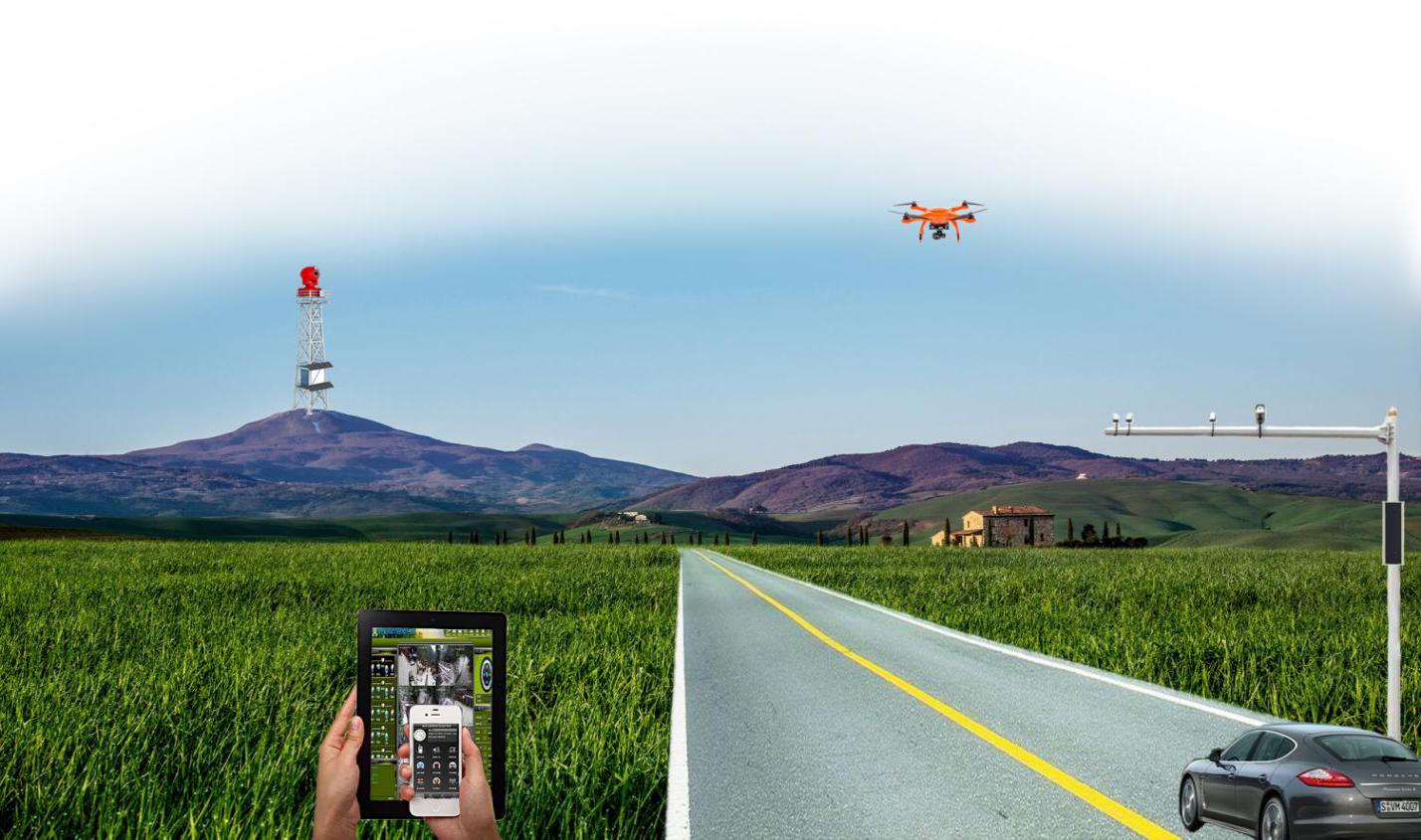
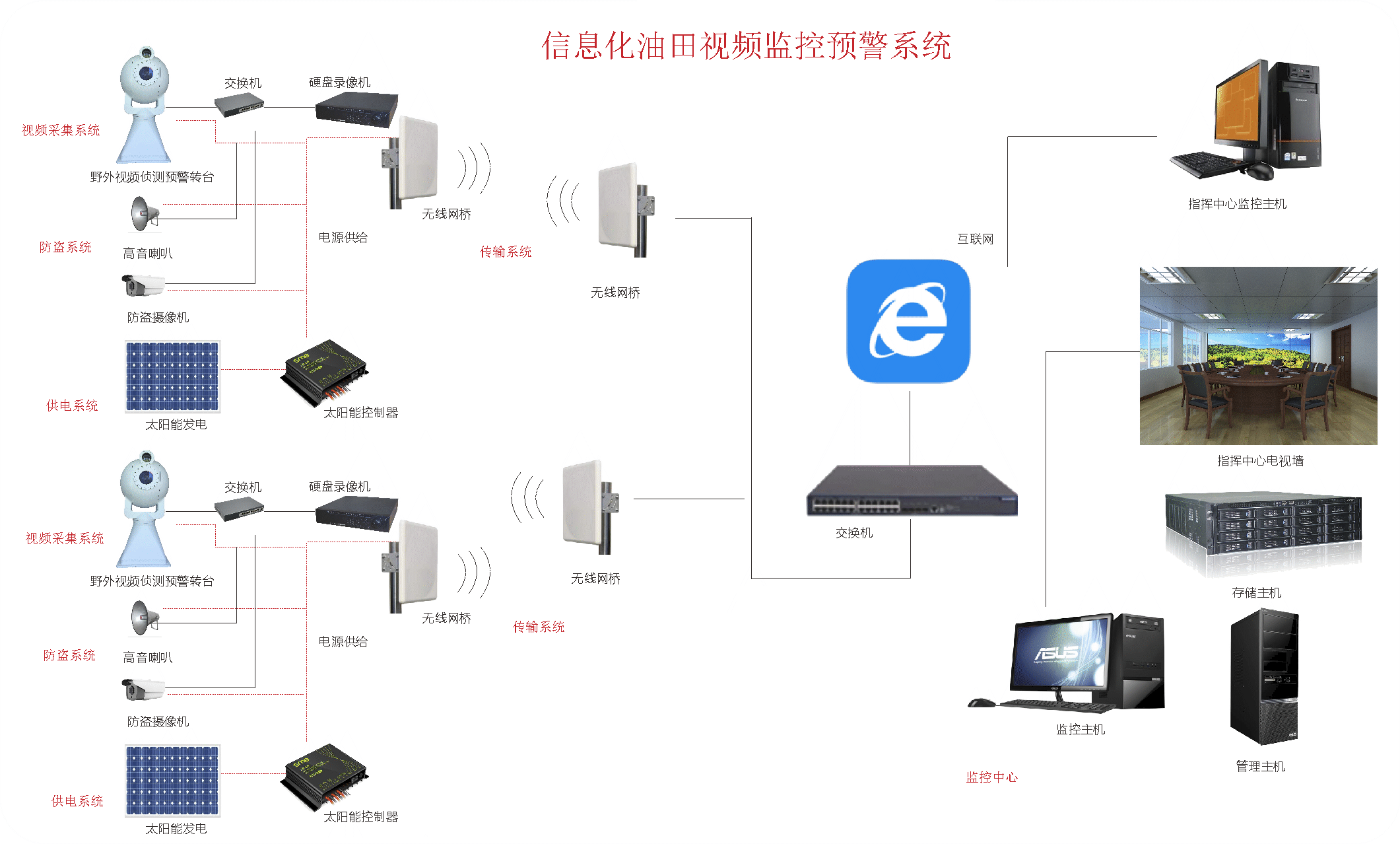
1 应用背景 当前中国经济的快速发展,石油天然气等能源产业在国家经济中的地位愈加显著。伴随着计算机技术、通信技术和视频技术的发展 ...

在我们赖以生存的地球上,森林成为人类繁衍生存必不可少的资源,目前全球的森林覆盖率为32 3%,森林资源在世界各地的分布也极不均匀。随着 ...
铁路是国民经济的大动脉,铁路运输安全不仅影响铁路本身的效率和效益,更直接影响了整个社会的生产生活和稳定和谐。铁路货物运输是铁 ...